Nautical Chart Types Explained
Nautical charts are indispensable tools for navigation, detailing water depths, hazards, landmarks, and marine environments. This article explores the various types of nautical charts, including paper, electronic, and specialized formats, while explaining their features, applications, and importance in safe maritime travel for recreational boaters, commercial mariners, and naval operators alike.
Nautical charts are detailed maps that guide mariners in navigating waterways safely and efficiently. They encompass critical information such as water depths, seabed features, coastal outlines, navigation hazards, and aids like lighthouses or buoys. With their precision and reliability, nautical charts are the backbone of maritime travel, enabling ships to traverse oceans, rivers, and lakes with confidence.
This guide will delve into the types of nautical charts, their unique characteristics, and their practical applications across various maritime activities.
1. Types of Nautical Charts
Nautical charts can be broadly classified into several categories, each tailored for specific uses and navigational needs.
A. Paper Charts
Paper charts are traditional, printed maps used for centuries. Despite the rise of electronic alternatives, paper charts remain popular for their simplicity and reliability.
- Key Features:
- Detailed symbols, scales, and color coding.
- Portable and do not rely on power sources.
- Easily annotated with pencil for updates.
- Applications:
- Backup navigation tools.
- Preferred by traditionalists and during electronic outages.
- Educational tools for teaching basic navigation.
- Challenges:
- Require manual updates to reflect changes.
- Bulky and less interactive than digital options.
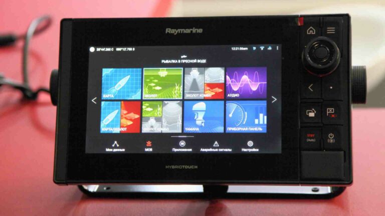
B. Electronic Navigational Charts (ENCs)
ENCs are digital maps specifically designed for use with electronic navigation systems.
- Key Features:
- Interactive and customizable.
- Continuously updated via online services.
- Integrates with GPS for real-time positioning.
- Applications:
- Used extensively by commercial ships and modern mariners.
- Enable route optimization and real-time hazard detection.
- Challenges:
- Depend on power and software integrity.
- Require technical proficiency to operate.
C. Raster Navigational Charts (RNCs)
Raster charts are scanned images of paper charts, offering a digital alternative with the same look and feel.
- Key Features:
- Exact replicas of paper charts.
- Compatible with electronic chart systems.
- Applications:
- Ideal for users transitioning from paper to digital formats.
- Challenges:
- Lack the interactivity of ENCs.
- Updates may not be as dynamic.
2. Specialized Nautical Charts
A. Coastal Charts
Designed for navigating coastal waters and harbors, these charts focus on shallow depths and nearshore hazards.
- Applications:
- Recreational boating and fishing.
- Harbor entry and exit.
B. General Charts
Used for open-sea navigation, these charts cover larger areas with less detail.
- Applications:
- Long-distance voyages.
- Route planning across major shipping lanes.
C. Bathymetric Charts
These charts focus on underwater topography, showing detailed depth contours and seabed features.
- Applications:
- Scientific research.
- Submarine and deep-sea operations.
D. Fishing Charts
Fishing charts highlight productive fishing areas, including depth data and seabed composition.
- Applications:
- Commercial and recreational fishing.
E. Harbor Charts
Highly detailed charts for navigating within ports and harbors, indicating berths, piers, and dock facilities.
- Applications:
- Docking and undocking.
- Harbor operations management.
3. Key Elements of Nautical Charts
Regardless of type, nautical charts share common elements essential for navigation:
- Scale: Indicates the level of detail. Smaller scales cover larger areas; larger scales are for close-range navigation.
- Depth Contours: Show variations in water depth.
- Symbols and Abbreviations: Standardized markers for navigation aids, hazards, and geographic features.
- Latitudes and Longitudes: Aid in precise location tracking.
- Tidal and Current Information: Crucial for determining safe routes and times.
4. How to Choose the Right Nautical Chart
Selecting the right chart depends on the type of vessel, voyage, and navigational requirements:
- For Recreational Boaters: Coastal or harbor charts for nearshore trips.
- For Commercial Mariners: ENCs for efficiency and safety in professional operations.
- For Research Purposes: Bathymetric charts for detailed underwater studies.
5. Maintaining and Updating Charts
Regular updates ensure charts reflect the latest maritime changes, such as new hazards or shifted navigation aids.
- For Paper Charts: Manual corrections using Notices to Mariners.
- For Digital Charts: Automatic updates via chart systems or software providers.
Conclusion
Nautical charts are indispensable tools for safe and efficient maritime navigation. Whether in traditional paper form or modern electronic formats, they serve a wide range of users with diverse needs. Understanding the types and features of nautical charts empowers mariners to make informed choices and navigate confidently in any waterway.
Happy Boating!
Share Nautical Chart Types Explained with your friends and leave a comment below with your thoughts.
Read Must Have Maintenance Products until we meet in the next article.