Marine Navigation: A Comprehensive Guide to Navigating the High Seas
Marine navigation is the art and science of guiding vessels across water bodies safely and efficiently. It integrates traditional techniques, modern technology, environmental awareness, and regulatory compliance. This article explores its history, methods, tools, challenges, and the evolving role of navigation in ensuring maritime safety and sustainability.
Marine navigation is fundamental to maritime operations, enabling vessels to traverse oceans, seas, rivers, and canals efficiently and safely. From ancient mariners using stars and landmarks to modern mariners relying on advanced electronic systems, navigation has evolved to meet the challenges of global trade and exploration.
History of Marine Navigation
- Ancient Techniques:
Early sailors relied on natural elements like the sun, stars, wind, and ocean currents. Tools like the astrolabe and sextant emerged to refine celestial navigation. - Age of Exploration:
In the 15th and 16th centuries, the magnetic compass and improved cartography played pivotal roles in global exploration. - Industrial Era:
The advent of steamships and modern port infrastructure necessitated more precise navigation tools, including the chronometer for accurate timekeeping. - Modern Era:
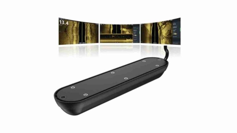
The development of radar, GPS, and Electronic Chart Display and Information Systems (ECDIS) has revolutionized navigation, making it safer and more efficient.
Key Methods of Marine Navigation
- Celestial Navigation:
Determining a vessel’s position using celestial bodies like the sun, moon, and stars with instruments like sextants and nautical almanacs. - Dead Reckoning:
Estimating position based on course, speed, time, and previous known positions, often combined with other methods for accuracy. - Electronic Navigation:
Utilizing GPS, radar, and AIS (Automatic Identification System) to provide real-time data on position and nearby vessels. - Pilotage:
Navigating using visual references like buoys, lighthouses, and coastlines, primarily in coastal or confined waters. - Electronic Charting:
Using ECDIS for detailed, interactive maps that incorporate real-time data and updates.
Essential Tools in Marine Navigation
- Traditional Tools:
- Compass
- Sextant
- Log line
- Lead line
- Modern Instruments:
- GPS (Global Positioning System)
- Radar
- Sonar
- Gyroscopic compass
- Software and Systems:
- ECDIS
- Integrated Bridge Systems (IBS)
- Weather routing software
Environmental and Safety Considerations
- Weather Forecasting:
Accurate weather predictions are critical for route planning to avoid storms, rough seas, and adverse currents. - Tides and Currents:
Understanding local tidal patterns and currents ensures safe passage, especially in narrow channels or during docking. - Environmental Regulations:
Compliance with international maritime laws, such as MARPOL, ensures minimal environmental impact during voyages. - Safety Protocols:
Emergency preparedness, collision avoidance systems, and adherence to the International Regulations for Preventing Collisions at Sea (COLREGs) are vital for safety.
Challenges in Marine Navigation
- Human Error:
Despite advanced tools, navigation errors often stem from poor training, fatigue, or miscommunication. - Equipment Failures:
Dependence on electronic systems makes vessels vulnerable to malfunctions or cyberattacks. - Adverse Weather:
Sudden weather changes pose significant risks, especially in remote or poorly charted waters. - Congestion:
Busy shipping lanes, ports, and straits require precise navigation to avoid collisions and delays.
The Future of Marine Navigation
- Automation and AI:
Autonomous ships equipped with AI-driven navigation systems are emerging, promising efficiency and reduced human error. - Sustainability Focus:
Eco-friendly navigation practices, such as route optimization to reduce fuel consumption, are gaining prominence. - Enhanced Connectivity:
Integration of real-time data from satellites and IoT devices ensures better situational awareness and decision-making. - Advanced Training:
Simulators and virtual reality are transforming maritime education, preparing mariners for complex navigation scenarios.
Conclusion
Marine navigation is an ever-evolving field that balances tradition with innovation. It remains critical to global trade, exploration, and safety at sea. By understanding its history, tools, methods, and future trends, we appreciate the intricate art and science that keeps vessels moving across the world’s waterways.
Happy Boating!
Share Marine Navigation: A Comprehensive Guide to Navigating the High Seas with your friends and leave a comment below with your thoughts.
Read Marine Chartplotters until we meet in the next article.