What is IMO’s Global Integrated Shipping Information System (GISIS)?
Discover the IMO’s Global Integrated Shipping Information System (GISIS), a vital platform for maritime data, enhancing safety, security, and environmental compliance.
The maritime industry, a cornerstone of global trade, relies on robust systems to ensure safety, security, and environmental sustainability. The Global Integrated Shipping Information System (GISIS), developed by the International Maritime Organization (IMO), stands as a pivotal tool in achieving these objectives. GISIS is an online platform designed to collect, process, and share critical maritime data, enabling stakeholders – ranging from governments and port authorities to ship operators and researchers – to make informed decisions. By centralizing information related to maritime safety, security, environmental protection, and regulatory compliance, GISIS promotes transparency and accountability across the global shipping industry. This article explores the structure, functionality, and significance of GISIS, detailing its modules, access mechanisms, and its role in advancing maritime operations.
Understanding GISIS: A Centralized Maritime Data Hub
The IMO, a United Nations specialized agency, oversees international maritime regulations to ensure safe, secure, and environmentally responsible shipping. GISIS, launched to support these goals, serves as a comprehensive database that consolidates data submitted by IMO Member States, maritime administrations, and port authorities. The platform facilitates compliance with IMO instruments, including conventions like the International Convention for the Safety of Life at Sea (SOLAS) and the International Convention for the Prevention of Pollution from Ships (MARPOL).
GISIS is structured into 26 modules, each addressing a specific aspect of maritime activity. These modules cover a wide range of topics, from maritime security and marine casualties to environmental protection and treaty ratification status. By providing a unified platform for data access and submission, GISIS streamlines operations, enhances regulatory oversight, and supports international collaboration.
Key Objectives of GISIS
GISIS serves multiple purposes, aligning with the IMO’s mission to promote safe, secure, and sustainable shipping. Its primary objectives include:
- Transparency: Making critical maritime data publicly accessible to foster accountability.
- Safety and Security: Providing data on hazards, incidents, and security measures to enhance maritime safety.
- Environmental Protection: Supporting compliance with environmental regulations through data on waste management, emissions, and ballast water treatment.
- Decision-Making: Enabling stakeholders to access reliable data for informed policy and operational decisions.
- Facilitation of Maritime Traffic: Streamlining port procedures and communication through accessible contact points and facility information.
GISIS Modules: A Comprehensive Overview
GISIS’s modular structure allows it to address diverse maritime needs. Below is a detailed exploration of its key modules, their purposes, and their contributions to the maritime industry.
1. Ship and Company Particulars
This module provides detailed information on ships and their owning companies, accessible via the IMO number – a unique identifier for vessels and registered companies. For sea-going merchant ships of 100 gross tonnage (GT) and above, the IMO number consists of the prefix “IMO” followed by a seven-digit number assigned by IHS Fairplay during construction. This number remains permanent, ensuring consistent tracking across a vessel’s lifecycle. Stakeholders can use this module to verify ship details, ownership, and compliance status, supporting regulatory oversight and operational transparency.
2. Maritime Security
The Maritime Security module compiles data required under SOLAS Chapter XI-2 and the International Ship and Port Facility Security (ISPS) Code. It includes information on piracy, armed robbery, and other security incidents, as well as port-specific security measures. This module enhances preparedness by enabling stakeholders to assess risks and implement appropriate security protocols.
3. Marine Casualties and Incidents
This module maintains a database of reported marine accidents and incidents, including detailed investigation reports and forms as per MSC-MEPC.3/Circ.3. The data supports safety analysis, risk assessment, and the development of preventive measures, contributing to safer maritime operations.
4. Port Reception Facilities
Aligned with MARPOL 73/78, this module lists global port facilities equipped to handle ship-generated waste, such as oily residues, sewage, and garbage. Users can filter data by area and port ID, ensuring ships can comply with environmental regulations by accessing appropriate waste reception facilities.
5. Pollution Prevention Equipment and Anti-Fouling Systems
This module catalogs equipment compliant with MARPOL and the Anti-Fouling Systems (AFS) Convention, including oil filters, ballast water management systems, and sewage treatment plants. The AFS sub-module details manufacturers, active ingredients, and approving authorities, promoting environmentally responsible ship operations.
6. Ship Fuel Oil Consumption
Introduced under MARPOL Annex VI, the Ship Fuel Oil Consumption module supports the IMO’s Data Collection System (DCS), mandatory for ships of 5,000 GT and above since January 1, 2019. These vessels, responsible for approximately 85% of CO2 emissions from international shipping, must report fuel consumption data annually. The process involves:
- Data Submission: Ships report aggregated fuel consumption data to their flag State by year-end.
- Verification: The flag State verifies compliance and issues a declaration by May 31.
- Data Transfer: Verified data is submitted to the IMO Ship Fuel Oil Consumption Database by June 30.
- Reporting: The IMO produces an anonymized annual report for the Marine Environment Protection Committee (MEPC).
This module supports the calculation of a ship’s Carbon Intensity Indicator (CII), aiding the IMO’s decarbonization goals. Data is accessible only to authorized administrations, with public reports anonymized to protect confidentiality.
7. Ballast Water Management
The Ballast Water Management (BWM) Convention module provides information on approved treatment systems, exemptions, and designated ballast water exchange areas. The Ballast Water Chemicals Database, developed by the GESAMP-Ballast Water Working Group, includes data on 41 chemicals commonly used in ballast water treatment, along with a calculation tool for compliance with BWM regulations.
8. Global Search and Rescue (SAR) Plan
This module lists national authorities and coordinators for maritime SAR operations, including contact details and rescue coordination centers. It enhances emergency response capabilities by ensuring stakeholders can quickly access relevant contacts.
9. Global Maritime Distress and Safety System (GMDSS)
The GMDSS module provides information on shore-based facilities for distress communication, organized by country. It supports rapid response to maritime emergencies, improving safety at sea.
10. Status of Treaties
This module tracks the ratification status of IMO conventions, detailing contracting states, entry-into-force dates, and global tonnage impacts. It provides insights into the adoption of international maritime regulations.
11. Other Notable Modules
- Simulators: Lists engine room and bridge simulators for maritime training, supporting skill development.
- Test Laboratories and Halon Facilities: Details facilities for fire testing and halon management, per the 2010 FTP Code.
- Evaluation of Hooks: Contains reports on lifeboat release systems, ensuring safety equipment reliability.
- Survey and Certification: Stores electronic certificates required under IMO conventions.
- Member State Audits: Supports the IMO Member State Audit Scheme by providing a platform for audit planning and reporting.
- National Maritime Legislation: Compiles national laws and regulations, enhancing regulatory transparency.
- Cargoes: Provides data on containers, bulk cargoes, and dangerous goods, supporting safe cargo handling.
Accessing GISIS: Public and Restricted Areas
GISIS offers flexible access to accommodate various users:
- Public Area: Accessible without registration, this area includes data on port reception facilities, treaty status, and reported incidents. It promotes transparency for general users, researchers, and the public.
- Registered Access: Users with an IMO web account can access additional modules, such as ship particulars and fuel consumption reporting tools. Registration is simple, requiring an email address.
- Member State Area: Reserved for IMO Member States, this area allows authorized users to upload compliance data and access restricted information.
- IMO Secretariat Area: Provides administrative access for managing registrations, compliance, and platform maintenance.
To explore GISIS, users can visit the official website at gisis.imo.org. The platform’s user-friendly interface and search functionality make it accessible to both technical and non-technical users.
The Role of GISIS in Maritime Operations
GISIS plays a transformative role in the maritime industry by centralizing critical data and supporting IMO objectives. Its contributions include:
Enhancing Safety and Security
By providing data on maritime security, casualties, and piracy, GISIS enables stakeholders to identify risks and implement preventive measures. For example, the Piracy and Armed Robbery module details incidents by ship name, time, and location, aiding navigation planning through high-risk areas.
Supporting Environmental Sustainability
GISIS modules on port reception facilities, pollution prevention equipment, and ship fuel consumption are instrumental in enforcing environmental regulations. The IMO DCS, for instance, tracks fuel consumption to monitor CO2 emissions, supporting global decarbonization efforts. The Ballast Water Management module helps prevent the spread of invasive species, protecting marine ecosystems.
Facilitating Regulatory Compliance
GISIS ensures compliance with IMO conventions by providing a platform for data submission and verification. The Survey and Certification module, for example, stores electronic certificates, while the Member State Audits module streamlines audit processes, enhancing regulatory oversight.
Enabling Informed Decision-Making
The platform’s comprehensive data supports policy development, operational planning, and research. Governments use treaty status data to align national policies, while ship operators rely on port facility information to plan voyages efficiently.
Promoting Transparency and Accountability
By making select data publicly accessible, GISIS fosters accountability in the maritime industry. Stakeholders can verify compliance, track incidents, and access contact points, ensuring transparent operations.
GISIS System Structure: A Mermaid Diagram
To illustrate the structure of GISIS, the following diagram outlines its access levels and key modules:
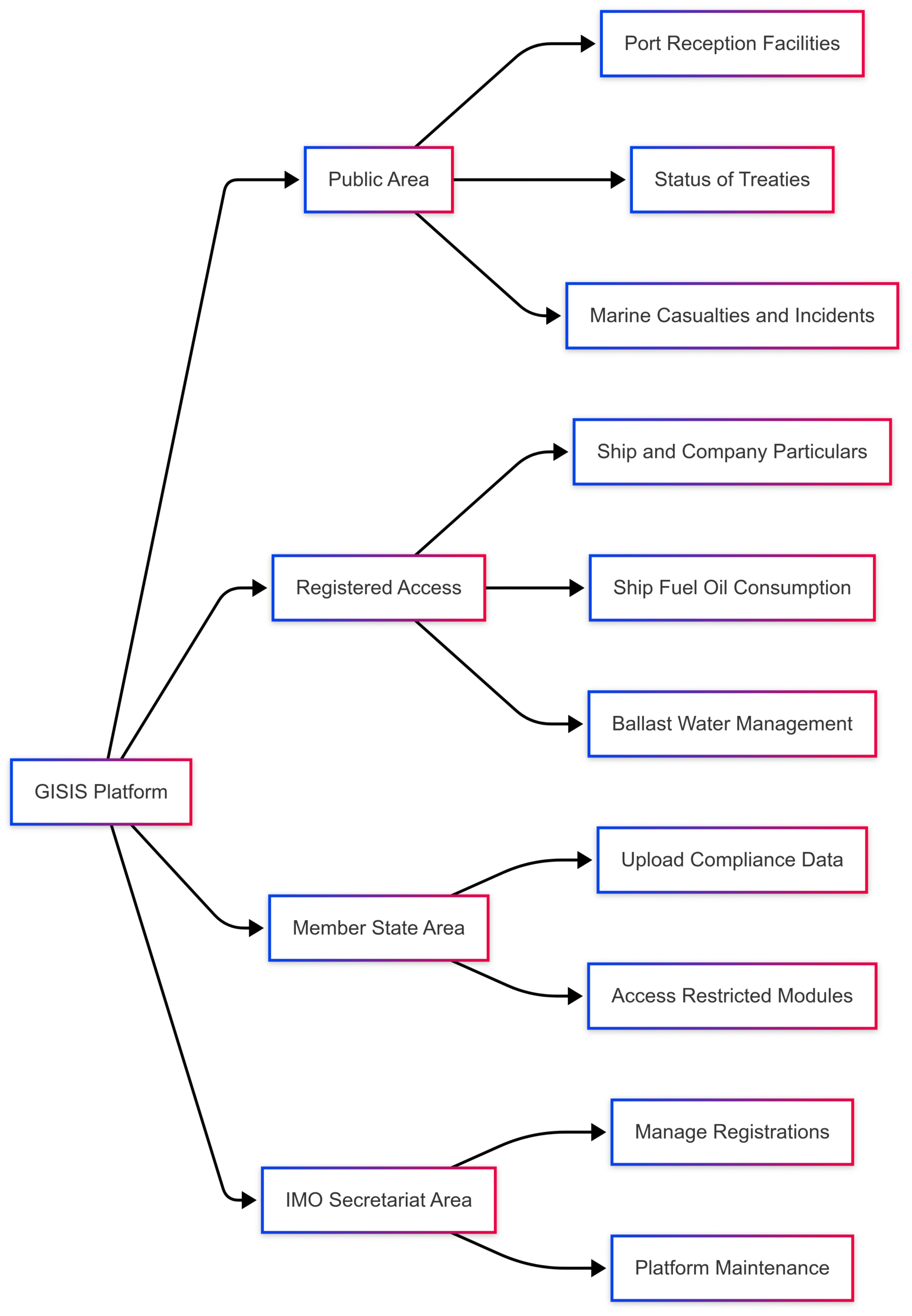
This diagram highlights the tiered access structure, ensuring that sensitive data is restricted while public information remains widely available.
Importance of GISIS in the Maritime Industry
GISIS is a cornerstone of modern maritime governance, offering several benefits:
- Centralized Data Repository: Consolidates diverse maritime data, reducing fragmentation and improving access.
- Global Collaboration: Facilitates information sharing among Member States, enhancing international cooperation.
- Regulatory Support: Simplifies compliance with IMO conventions through standardized data submission and verification processes.
- Research and Analysis: Provides a wealth of data for studying maritime trends, incidents, and environmental impacts.
The IMO’s ongoing efforts to improve GISIS, including a recent user survey, underscore its commitment to enhancing the platform’s functionality. The survey, aimed at Member States, international organizations, and public users, seeks feedback on search functionality, navigation, and data presentation. Findings will inform upgrades to GISIS, ensuring it remains a robust tool for maritime stakeholders.
Challenges and Future Directions
While GISIS is a powerful platform, it faces challenges such as ensuring data accuracy, enhancing user experience, and integrating advanced analytics. The IMO’s review of GISIS aims to address these issues by:
- Improving Functionality: Enhancing search capabilities and user interface for better accessibility.
- Expanding Data Analytics: Developing GISIS as a primary repository for operational data to support policy development.
- Ensuring Data Integrity: Strengthening verification processes to maintain accurate and reliable data.
The IMO’s IT-enabled programme for data analysis, launched recently, aims to leverage GISIS for advanced data utilization, supporting evidence-based decision-making.
Conclusion
The Global Integrated Shipping Information System (GISIS) is a vital tool in the maritime industry, enabling stakeholders to navigate the complexities of global shipping with confidence. By providing access to critical data on safety, security, environmental compliance, and regulatory adherence, GISIS supports the IMO’s mission to foster safe, secure, and sustainable maritime operations. Its modular structure, tiered access, and comprehensive datasets make it an indispensable resource for governments, ship operators, port authorities, and researchers. As the IMO continues to refine GISIS through user feedback and technological advancements, the platform will remain a cornerstone of maritime governance, driving transparency, accountability, and innovation in the industry.
FAQs
What is the purpose of GISIS?
GISIS provides a centralized platform for accessing and sharing maritime data, supporting regulatory compliance, safety, security, and environmental protection.
Who can access GISIS?
Public users can access select data without registration, while an IMO web account grants access to additional modules. Member States and the IMO Secretariat have restricted access for compliance and management.
How does GISIS support environmental protection?
Modules on port reception facilities, pollution prevention equipment, ballast water management, and ship fuel consumption help monitor and enforce environmental regulations.
How is the IMO number used in GISIS?
The IMO number uniquely identifies ships and companies, enabling stakeholders to access detailed particulars and compliance data through GISIS.
Can researchers use GISIS?
Yes, GISIS provides valuable data on incidents, ship particulars, and treaty status, supporting research in maritime safety and policy.
Happy Boating!
Share What is IMO’s Global Integrated Shipping Information System (GISIS)? with your friends and leave a comment below with your thoughts.
Read Evaluating differences between maritime accident databases until we meet in the next article.