Vessel Traffic Services (VTS): Enhancing Maritime Safety
Discover how Vessel Traffic Services (VTS) enhance maritime safety, efficiency, and environmental protection using radar, AIS, and real-time monitoring.
Maritime transport is the backbone of global trade, with over 50,000 active vessels navigating the world’s oceans, rivers, and ports. As maritime traffic grows, so does the risk of collisions, groundings, and environmental disasters. Vessel Traffic Services (VTS) have emerged as a critical tool to manage these risks, ensuring the safety of vessels, crews, and the marine environment. Comparable to air traffic control for aviation, VTS systems monitor and guide vessels in congested or hazardous areas, reducing accidents, optimizing traffic flow, and minimizing environmental damage. This comprehensive guide explores how VTS works, its technologies, benefits, challenges, and global impact, providing a deep dive into its role in modern maritime operations.
What Are Vessel Traffic Services?
Vessel Traffic Services are shore-based systems designed to improve the safety, efficiency, and environmental sustainability of maritime traffic. Operated by coastal authorities, such as the United States Coast Guard, VTS systems monitor vessel movements, provide navigational guidance, and coordinate traffic in high-risk or high-traffic areas like ports, coastal waters, and inland waterways. By leveraging advanced technologies like radar, Automatic Identification System (AIS), and VHF radio communication, VTS ensures vessels navigate safely, avoid collisions, and comply with regulations.
The International Maritime Organization (IMO) defines VTS as a service that enhances the safety of life at sea, improves navigational efficiency, and protects the marine environment from the adverse effects of maritime traffic. VTS operates under the International Convention for the Safety of Life at Sea (SOLAS), with guidelines established by the IMO and the International Association of Marine Aids to Navigation and Lighthouse Authorities (IALA).
Core Objectives of VTS
VTS systems are built around three primary objectives:
- Safety of Navigation: Preventing collisions, groundings, and other incidents by monitoring vessel movements and issuing warnings.
- Traffic Efficiency: Streamlining vessel movements to reduce delays, congestion, and fuel consumption in busy ports and waterways.
- Environmental Protection: Minimizing the environmental impact of maritime activities by optimizing routes, reducing emissions, and preventing incidents like oil spills.
How Vessel Traffic Services Work
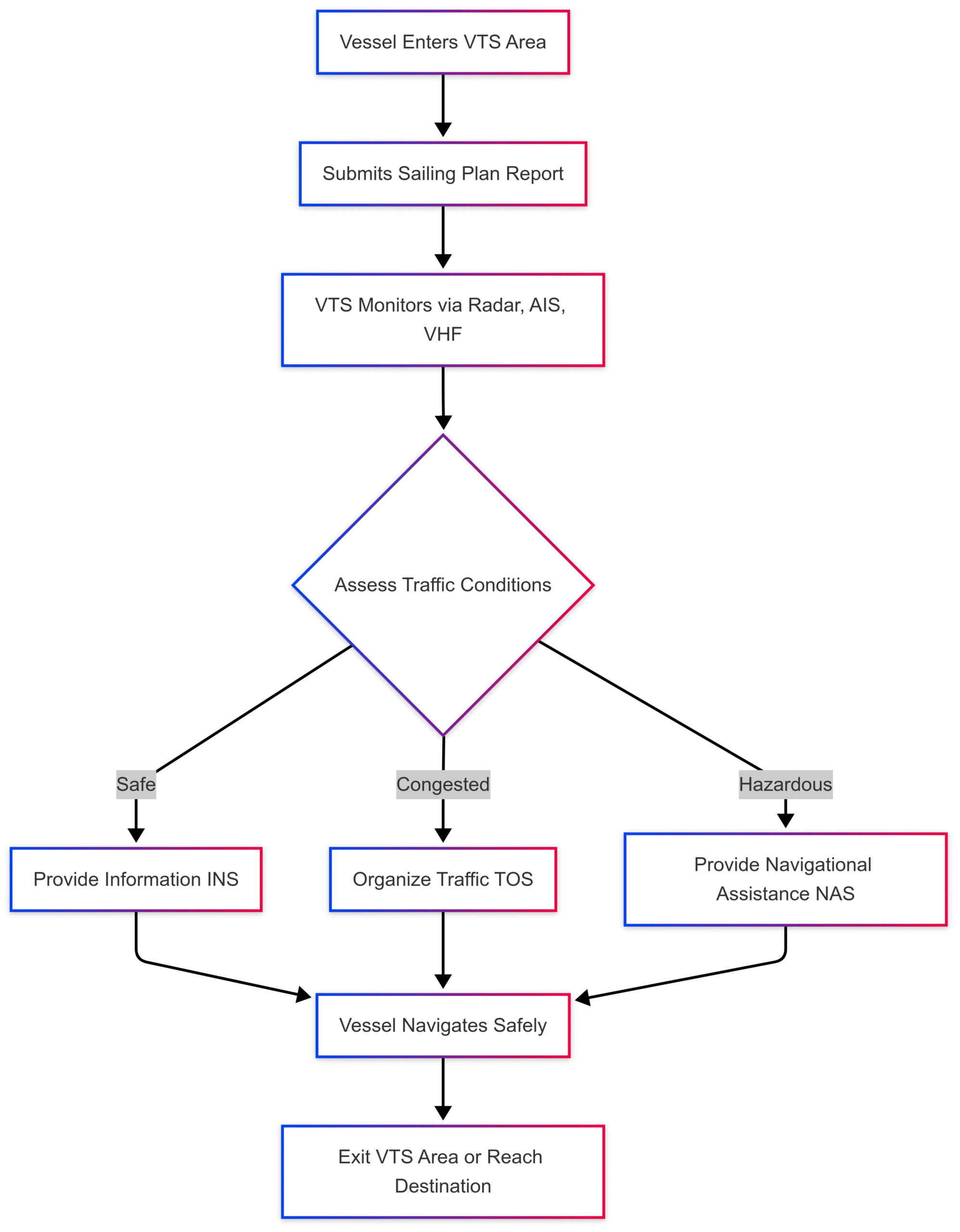
VTS systems function as the eyes and ears of maritime traffic management, combining advanced technology with skilled operators to ensure smooth and safe navigation. The system operates through three main services:
1. Information Service (INS)
The Information Service provides vessels with real-time data on weather conditions, traffic density, navigational hazards, and other critical updates. This empowers shipmasters to make informed decisions, particularly in challenging environments like foggy waters or busy ports. For example, VTS operators may broadcast warnings about temporary obstructions, such as a disabled vessel or construction work in a shipping lane.
2. Traffic Organization Service (TOS)
The Traffic Organization Service focuses on managing vessel movements to prevent congestion and ensure efficient traffic flow. VTS operators may assign specific routes, schedule arrival and departure times, or enforce speed limits to maintain order in high-traffic areas. This service is critical in ports where dozens of vessels may be maneuvering simultaneously.
3. Navigational Assistance Service (NAS)
In situations where vessels face navigational challenges—such as poor visibility, equipment failure, or complex waterways—VTS operators provide direct guidance. This may include advising on course adjustments or coordinating with pilots to ensure safe passage.
VTS Workflow Diagram
The following Mermaid diagram illustrates the workflow of a VTS system:
Technologies Powering VTS
VTS systems rely on a suite of technologies to monitor and manage maritime traffic effectively. These include:
1. Radar Systems
Radar is the backbone of VTS, enabling operators to track vessel positions, speeds, and courses in real-time. Modern radar systems can detect vessels in adverse weather conditions, such as heavy rain or fog, ensuring continuous monitoring.
2. Automatic Identification System (AIS)
AIS is a transponder-based tracking system that broadcasts a vessel’s identity, position, speed, course, and other data. Since 2004, SOLAS regulations mandate AIS for all vessels over 300 gross tonnage on international voyages. AIS data is transmitted via VHF radio frequencies (161.975 MHz and 162.025 MHz) using Self-Organized Time-Division Multiple Access (SOTDMA). This allows VTS centers and nearby vessels to receive real-time updates, enhancing situational awareness.
AIS Data Categories
| Category | Frequency | Information Provided |
|---|---|---|
| Static Information | Every 6 minutes | Vessel identity, IMO number, length, beam, type |
| Dynamic Information | Varies (speed/course) | Position, speed, course, navigational status |
| Voyage Information | Every 6 minutes | Cargo type, destination, ETA, route plan |
3. VHF Radio Communication
VTS operators use VHF radio to communicate directly with vessels, issuing instructions, warnings, or navigational advice. Vessels are required to monitor specific VHF channels within VTS areas to receive updates.
4. Surveillance Cameras
High-resolution cameras, often equipped with night vision or thermal imaging, provide visual monitoring of critical areas like port entrances or narrow channels. These cameras complement radar and AIS, offering a visual confirmation of vessel activities.
5. Electronic Chart Display and Information Systems (ECDIS)
ECDIS integrates AIS, radar, and digital nautical charts to provide a comprehensive view of maritime traffic. VTS operators and shipmasters use ECDIS to plan routes and avoid hazards.
6. Satellite-AIS (S-AIS)
For vessels beyond the range of terrestrial AIS (approximately 20 miles), Satellite-AIS captures signals and relays them to VTS centers. This ensures global tracking, even in remote oceanic regions.
Types of VTS Systems
VTS systems are tailored to the specific needs of their operational areas. The three main types are:
- Port VTS: Manages vessel traffic in and around ports, focusing on safe berthing, arrivals, and departures. Example: Los Angeles/Long Beach VTS.
- Coastal VTS: Monitors larger coastal regions, protecting shipping lanes and environmentally sensitive areas. Example: Puget Sound VTS.
- River VTS: Oversees traffic on inland waterways, ensuring safe navigation in narrow or congested rivers. Example: Saint Mary’s River VTS.
Global VTS Operations
The United States Coast Guard operates 12 VTS centers, including:
- Prince William Sound
- Puget Sound
- Valdez
- Seattle
- San Francisco
- Los Angeles/Long Beach
- Houston-Galveston
- Berwick Bay
- Louisville
- Saint Mary’s River
- Port Arthur
- Tampa
- New York
Each center is equipped with radar, AIS, VHF radio, and surveillance systems tailored to its operational area. Globally, VTS systems are implemented in over 165 countries, with more than 2,000 AIS stations supporting real-time maritime tracking.
Historical Development of VTS
The concept of VTS evolved with advancements in maritime communication and tracking technologies. In the late 19th century, ships used flag signals to announce their arrival at ports. The advent of radio communication in the early 20th century improved coordination, but the introduction of radar during World War II revolutionized maritime tracking.
The first harbor surveillance radar was installed in Liverpool, UK, in 1948, followed by Long Beach, California, in 1950. These systems laid the foundation for modern VTS. The IMO formally recognized VTS in 1968 with Resolution A.158, followed by standardized guidelines in 1985 (Resolution A.578) and 1997 (Resolution A.857). In 2021, the IMO updated these guidelines with Resolution A.1158(32) to reflect technological and operational advancements.
Regulatory Framework
VTS operations are governed by international standards under SOLAS Regulation V/12, which allows governments to establish VTS in areas with high traffic or risk. The IMO and IALA provide guidelines on VTS implementation, operator training, and equipment standards. Key principles include:
- VTS is mandatory only within a coastal state’s territorial waters.
- VTS does not override the shipmaster’s authority over navigation decisions.
- Governments must ensure compliance with VTS regulations for vessels under their flag.
IALA’s standards ensure global harmonization, covering operator qualifications, system interoperability, and best practices for traffic management.
Benefits of Vessel Traffic Services
VTS systems deliver significant benefits across safety, efficiency, and environmental protection.
1. Enhanced Safety
By monitoring vessel movements and issuing real-time warnings, VTS reduces the risk of collisions, groundings, and other incidents. For example, in congested areas like the English Channel, VTS operators can alert vessels to potential hazards, preventing accidents.
2. Improved Efficiency
VTS optimizes vessel routing and scheduling, reducing port congestion and delays. This minimizes fuel consumption and operational costs for shipping companies. A 2018 UNCTAD review highlighted that efficient traffic management can save millions in fuel costs annually.
3. Environmental Protection
VTS minimizes environmental risks by enforcing regulations in sensitive areas, such as coral reefs or marine sanctuaries. By optimizing routes and reducing idling, VTS also lowers greenhouse gas emissions. In emergencies, such as oil spills, VTS coordinates rapid response to mitigate damage.
4. Support for Search and Rescue
VTS provides critical data during search and rescue operations, including vessel positions and navigational status, enabling faster and more effective responses.
5. Accident Investigation
AIS and radar data from VTS systems provide accurate historical records for accident investigations, helping authorities determine causes and improve safety protocols.
Challenges and Limitations
Despite its benefits, VTS faces several challenges:
- Data Accuracy: The reliability of AIS data depends on the accuracy of transmitted information. Incorrect or outdated data can compromise safety.
- Incomplete Coverage: Not all vessels, such as those under 300 gross tonnage, are required to carry AIS, limiting VTS visibility.
- Geographical Constraints: Terrestrial AIS has a range of about 20 miles, requiring Satellite-AIS for global coverage.
- Coordination Complexity: In busy ports, coordinating multiple vessels with varying priorities can be challenging for VTS operators.
- Cost of Implementation: Establishing and maintaining VTS systems requires significant investment in technology and training.
User Reviews of VTS Systems
To provide a balanced perspective, here are insights from maritime professionals and vessel operators based on their experiences with VTS systems:
Pros
- Enhanced Situational Awareness: “VTS gives us real-time updates on nearby vessels, which is critical in foggy conditions or busy ports.” – Ship Captain, Port of Rotterdam.
- Efficient Port Operations: “The TOS service has reduced our waiting times at the port, saving fuel and improving turnaround times.” – Fleet Manager, Houston-Galveston.
- Environmental Benefits: “VTS helps us avoid sensitive areas, reducing the risk of environmental violations.” – Environmental Compliance Officer.
Cons
- Communication Overload: “In high-traffic areas, the constant VHF radio chatter can be overwhelming, making it hard to focus.” – Ship Navigator.
- Dependence on AIS: “If a vessel doesn’t have AIS or it’s malfunctioning, VTS can’t track it effectively.” – VTS Operator.
- Cost Concerns: “Smaller operators struggle with the costs of equipping vessels with AIS and complying with VTS regulations.” – Small Vessel Owner.
VTS Equipment Specifications and Costs
The cost of VTS systems varies depending on the scale and complexity of the operation. Below is a table outlining typical equipment and estimated costs for a VTS center:
| Component | Specifications | Estimated Cost (USD) |
|---|---|---|
| Radar System | High-resolution, 360° coverage, 20-mile range | $500,000 – $1,000,000 |
| AIS Transponder (Class A) | VHF-based, SOTDMA, global compatibility | $2,000 – $5,000 per unit |
| VHF Radio System | Multi-channel, long-range communication | $10,000 – $50,000 |
| Surveillance Cameras | HD, night vision, thermal imaging | $20,000 – $100,000 |
| ECDIS Software | Real-time chart integration | $5,000 – $20,000 |
| Satellite-AIS Receiver | Global coverage, high sensitivity | $100,000 – $500,000 |
Note: Costs are approximate and vary based on region, vendor, and system scale. For detailed pricing, consult vendors like Kongsberg or Raytheon.
The Future of VTS
As maritime traffic continues to grow, VTS systems are evolving to meet new challenges. Emerging technologies, such as artificial intelligence (AI) and machine learning, are being integrated to enhance predictive analytics and automate traffic management. For example, AI can analyze AIS data to predict potential collisions or optimize routes in real-time. Additionally, the expansion of Satellite-AIS is improving global coverage, enabling VTS to monitor vessels in remote regions.
The IMO and IALA are also exploring ways to standardize VTS operations further, ensuring interoperability across regions. With increasing emphasis on sustainability, VTS systems are expected to play a larger role in reducing maritime emissions and protecting marine ecosystems.
Conclusion
Vessel Traffic Services are a cornerstone of modern maritime navigation, ensuring the safety, efficiency, and environmental sustainability of vessel movements. By leveraging technologies like radar, AIS, and VHF communication, VTS systems prevent accidents, streamline traffic, and protect fragile marine environments. Despite challenges like data accuracy and implementation costs, the benefits of VTS far outweigh its limitations, making it an indispensable tool for global maritime operations.
As technology advances and maritime traffic grows, VTS will continue to evolve, incorporating AI, enhanced satellite tracking, and global standards to meet the demands of a dynamic industry. For port authorities, ship operators, and environmental regulators, VTS remains a critical asset in safeguarding the seas and ensuring the smooth flow of global trade.
Happy Boating!
Share Vessel Traffic Services (VTS): Enhancing Maritime Safety with your friends and leave a comment below with your thoughts.
Read Best and top rated marine speakers until we meet in the next article.